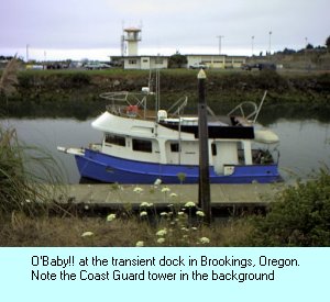
Brookings to Bandon
August 30, 2000
 The night before, following the Coast Guard inspection, the Coast
Guard personnel told us we could expect nasty weather coming in from the northwest. Couple
this with Debbie's observations of Cape Blanco as always being nasty and you can
understand our nervousness about departing this morning. Even though NOAA weather radio
had a rather genteel report, we figured that the Coast Guard guys knew something more than
what we could gather from the weather broadcast.
The night before, following the Coast Guard inspection, the Coast
Guard personnel told us we could expect nasty weather coming in from the northwest. Couple
this with Debbie's observations of Cape Blanco as always being nasty and you can
understand our nervousness about departing this morning. Even though NOAA weather radio
had a rather genteel report, we figured that the Coast Guard guys knew something more than
what we could gather from the weather broadcast.
If you've read many of these accounts of our trip, then you should
recognize by now that anxiety
and nervousness
are frequently used
words in this narrative. That's because we are so unfamiliar with what we're attempting
that each leg presents itself as a new experience. With unfamiliarity comes anxiety.
We left the dock and the channel of the Chetco River early that morning,
pointed O'Baby!! north and hoped for the best. As was the case with every previous
departure, we were ready to turn back to calmer waters at the first sign of adversity. We
would need much more experience before we would tackle the sea in anything but calm
conditions.
Staying relatively close to shore, we made our way north. Pleasantly, the
seas were as friendly as they had been in most of our previous departures during this
week.
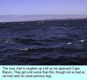 The wind picked up as we approached Cape
Blanco, but since this was expected, and didn't exceed our threshold of bad weather, we continued
on. Once again, after careful consideration of the charts, we made the decision to go through the
reef off Cape Blanco rather than the long way around it.
The wind picked up as we approached Cape
Blanco, but since this was expected, and didn't exceed our threshold of bad weather, we continued
on. Once again, after careful consideration of the charts, we made the decision to go through the
reef off Cape Blanco rather than the long way around it.
As we came abeam of Cape Blanco, the water turned a brownish color. In
addition, I saw what looked like a whale spout directly in our path. Looking for any sign
of a whale yielded nothing. The depth gauge showed us in 80' of water. Regardless, I was
concerned that what I saw was a breaker on a submerged rock and turned away from that path
and the shore to deeper water. Debbie was busy taking pictures of the Cape Blanco
lighthouse and wasn't totally aware of this deviation. She subsequently saw the same thing
I did and immediately came to understand why our course had changed. Talking this over, we
both decided it would be prudent to continue the course away from the shore till we were
clear of the brown water (the depth still showed 80' or better).
Shortly after clearing the Cape Blanco area, the seas calmed down to their
previous condition. We then continued on our plotted course to Bandon.
An hour or so after passing Cape Blanco, in calm seas, with Debbie taking
the helm, I sat down in the last remaining seat to rest my feet. I like the stand-up helm,
but it does take a toll on your feet after awhile. While seated and gazing out at the sea
and landscape, I had a terrible feeling of deja vu. Suddenly, and without warning, I was
falling over backwards. The seat I was sitting in broke, just as it did the day before!
The weld on the seat post had broken!
We had hundreds of hours in these seats over the past year, in calm seas
as well as those that scared the daylights out of us. And nary a problem. But in two
consecutive days, in calm weather, both seats had broken in exactly the same way. What are
the odds on that? Astronomical, I'm sure. So here we are, no seats on the flybridge. Thank
goodness we weren't far from Bandon.
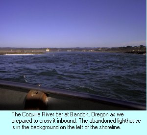 Approaching Bandon on a following sea, with no
bar report (the Coast Guard was out on practice manuvers), we made our way toward the entrance.
Getting closer we could see that the bar was a bit rough. Estimating the breakers at about four
feet, we continued in nonetheless.
Approaching Bandon on a following sea, with no
bar report (the Coast Guard was out on practice manuvers), we made our way toward the entrance.
Getting closer we could see that the bar was a bit rough. Estimating the breakers at about four
feet, we continued in nonetheless.
Going over the bar wasn't easy, the following seas tended to move the
stern this way and that. But it wasn't impossible to control, as long as you stayed on top
of the heading. It was an interesting ride though, and our first experience with a rough
bar. We made it through just fine though and made our way toward the transient dock (as
depicted in our chart guide) all the while trying to contact the Bandon Harbormaster on
all the common VHF frequencies. With no luck, I might add.
Turning the corner into the boat basin, it quickly became obvious that the
transient dock wasn't what it was supposed to be. There were Bandon charter boats taking
up that dock. Not a problem, though. Never one to be shy, we just took the first available
end-tie and called that good. If we were in the wrong place, someone would let us know.
Right? So we tied up, found some electricity, filled the water tanks, and settled in for
the night once again. All the while wondering, just where are those fuel pumps the chart
guide mentions?
We'd made it a little farther toward our goal of the Columbia River
without incident. We were safely tied up in a harbor. It's Miller time!